Monday, September 28, 2009

John Muir Wilderness Area,The Little Lakes Valley Trailhead


High above the treeline a terminal moraine marked the end of a cirque,(a bowl shaped depression formed from an alpine glacier). There had to be a lake up there, like Lost Twin Lakes in the Bighorns. Alan pointed out the trail to it and mentioned that he had seen the trail break off from our path. Today was not the day, but the cirque and its hidden lake beckoned,(We looked it up and its called Hidden Lakes).
We were hiking the Little Lakes Valley Trail, high up in the Sierras Nevadas. We had parked the truck at the trail head, donned our packs, and headed for the wilderness area. Immediately the trail steepened, much tougher than climbing Lembert Dome, and we paused as we hiked up a section called the crankcase,(It used to be a road and it didn't take much imagination as to how many vehicles broke their crankcase on the rocky path).
We reached a fork and headed up the Little Lakes trail, the other way went to Mono Pass. Soon we reached a lake and then another. As we hiked we could see that the whole valley was a series of paternoster lakes, a French alpine glacier term describing a chain of lakes carved out by a single alpine glacier,(They were so named because they resembled the rosary beads of a priest).The aspens shared their brillant fall colors with us with groves of yellow and orange trees. It was a perfect time to see the fall mountains display.
We stopped at Marsh Lake for pictures and lunch, before heading further up the trail to Heart and Long Lakes. Our cameras were clicking furiously and we made our final stop at Long Lake where we rested and talked. Others passed us both ways as the trail was busy with hikers all looking for a last breath of the high mountain air. Too soon snow would fly and fill the passes and trails, covering all in the winters cold grip.
We didn't make it to Chickenfoot lake, which was our original destination, but that was fine. Our cameras cards and more importantly our minds were full of images of the beauty of the high Sierras. The hike back was pretty easy as it was mostly downhill and it went too quickly. We all felt lucky, and blessed to spend a day with friends, in the high country. Clear skies.

Saturday, September 26, 2009

Canoeing Convict Lake, California


The water was some of the bluest we had ever seen. Not quite as blue as Crater Lake but still a distinct blue. Looking down we could see at least twenty feet deep, which is pretty typical for a glacial cirque lake. Above us Mount Morrison reared its rocky flat irons, and a hanging valley spoke of past glaciers. We could see why Alan and Sharon had took us there and why Alan had said it was one of his favorite places.
We launched the canoe and kayaks at the boat ramp and quickly left the protected marina. As we paddled Renita spotted a Clarks Nutcracker, perched atop a dead tree.
Alan paddled too close to a fisherwomen on shore who grumpily stated that boaters needed to stay at least 25 yards from fishermen, hmmmm never heard of that before?
The surface stayed calm only broken by an occasional trout rising to feed on an unfortunate grasshopper. There were quite a few boats fishing and many people from shore, we saw one catch a pretty large rainbow. You wonder how many of the fish are stocked as the lake seems pretty small and the large numbers of fisherman made it seem that the trout wouldn't last long.
We beached our boats at the upper end of the lake and were greeted by a flock of nutcrackers, who seemed intent on arguing among themselves about some bird affront.
I waded out and rolled some rocks looking for caddis larve, encased in their rocky tubes. I found some right away and it was obvious the water quality was excellent.
Returning the critters to their home we paddled further and Alan and Sharon used a stream for a free push for their kayaks. Renita and I both paddled a bit in their kayaks and really enjoyed the ease with which they sped across the water. They were a lot more stable then the sit on top kayak I had tried at Rockport.
We ate lunch and talked and scared some more fisherman away. More trout feed on more grasshoppers, couldn't the fisherman see that bite? The wind picked up a bit and we paddled back to the marina,(all though its really just a protected landing with a small building). Loading our boats we checked out the campground for future visits but it seemed the spots were too small for our rig and I told Renita to cross it off our list.
The lake itself had been a great paddle, deep and clear and surprisingly warm but it was early fall and no cold fronts had blasted across the area to cool the water. The aspens were changing and we could see it wouldn't be long before winter returns to the high country. Another fine day with friends. Clear skies.

Friday, September 25, 2009

Yosemite National Park, Climbing Lembert Dome


We had both felt the granite calling to us, as we hiked Tuolumne Meadows, and so we returned for a hike/climb to the top of Lembert Dome. The website summitpost.com had said that the trail from the Dog Lake parking lot was really an easy hike to the top, and so we decided to take that route.
Both of us were nervous as we started up the trail and we could feel the effects of the thin air at 9000 feet. We stopped frequently and looked for birds and wildlife. Towhees were everywhere and during one rest we were rewarded with a doe and her fawn, grazing nearby.
Now the hike from the parking area is really short, only eight tenths of a mile, with an 850 foot elevation gain, and we soon reached the trail junction and turned west towards the summit ridge. Leaving the trees behind we walked and gazed at the distant peaks. The rock was a beautiful white granite with large crystals of feldspar, which provided great hand holds and footholds, maybe the best face climbing rock I have ever been on.
Wanting to run, I went ahead checking for the easy way to the summit. Turning I saw that Renita was right behind me and so we pushed on with little thought of stopping.
As we neared the top we had to scramble a bit but there was an obvious scar that led to the peak. Above us the way was blocked by another hiker who was feeling the acrophobia, but she finally moved up with encouragement form her partner, and we followed and reached the summit.
Enjoying the view we pointed out places and too soon other climbers reached the small top and it actually became crowded! The wind came up and I feared that it would soon become too strong for a safe down climb and so we left the exposed top for a more protected spot for lunch. As we sat and ate lunch a bald eagle soared above us. I glassed the southwest face looking for obvious climbing routes, and we both watched the cars far below.
The return hike was easy and fast. The whole route had taken less then three hours and that was because we had stopped for lunch and scenery. Agreeing that this was a definite place to return to again, we loaded our days packs into the truck, for the short drive home. Clean hard rock, a high place, and an eagles view of Tuolumne Meadows! Clear skies.

Obsidian Dome, Near June Lake, California


Imagine a wall of broken black glass and each boulder and outcrop having edges sharper than then sharpest steel scalpel. A single slip on the edge of a boulder and catastrophe! As I climbed down I carefully placed my foot and then tested it for movement, before releasing my handhold and looking for another. Slipping, my calf grazed a boulder but it was a pumice block, I had been lucky. Why had I ever climbed up!
We still had quite a bit to do on our list of musts. One was to visit Obsidian Dome and another was to climb Lembert Dome in Yosemite National park. Having to do some grocery shopping we went to Mammoth Lakes and then returned home for lunch before driving to Obsidian Dome.
Now Obsidian Dome is an upwelling of lava that quickly cooled and turned into glass before crystals could form. It formed a black glass with visible flow lines of pumice, where the lava had frothed as gasses had been released. Looking at the black spires I saw an easy way up, and down, and so I started up the talus of huge blocks of obsidian interspersed with pumice.
As I climbed, scrambled really, I looked back and saw Renita wisely walking along the base of the cliff. Stopping often I hit some of the boulders with my hammer and they were so solid that my hammer simply bounced off the solid glass! Reaching the top I saw that it was covered with spires of glass and for the first time decided that climbing them would be less then wise.
There was beautiful volcanic glass all around me but picking some up I realized that I didn't want the weight for the down climb. Meanwhile. I looked down and saw Renita had returned with her hands full of obsidian, so I started down and for the first time understood the risk involved.
It wasn't steep, or even terribly difficult, but the sharp glass edges were a reminder of the ever present danger. I had to use some for handholds, and they were solid, but still sharp. I stepped on one edge and it felt like I was standing on the edge of a razor but it didn't cut through my shoe.
Safely reaching the bottom of the glass wall. Renita showed me her samples. We hiked along the base and she pointed out the beautiful flow lines of pumice and obsidian. Returning to the truck we loaded our samples,(more weight for the fifth wheel don't you know), and drove back home. What a crazy place! Clear skies.

Monday, September 21, 2009

Yosemite National Park. Hiking Tuolumne Meadows


The view to the west was quite spectacular,the Cockscomb, Unicorn Peak, Pothole Dome, and Cathedral Peak all spoke of hard granite. Each was uniquely shaped but Catherdral Peak and the Unicorn spoke loudest. To the east Lembert Dome rose above 9000 feet and we could see the hikers and climbers dotting its sides. It reminded us of the sandstone wall one hikes up to reach Delicate Arch at Arches National Park, but this looked steeper.
We were on a days hike in Yosemite National Park, guided and joined for the day with Sharon and Alan Frey. Retired California teachers and Yosemite experts, they had wanted to take us on a hike and share their knowledge and love of Tuolumne Meadows. We couldn't have had better companions.
Hefting our day packs, we left our truck and hiked along the road for a bit before entering the meadow. The dried brown grasses and sedges were interspersed with small hillocks that spoke of a wetter season. As we hiked I kept expecting to see a moose or elk, but we saw no scats or tracks, so obvious when an area contains them.
We crossed the Tuolumne River on a substantial footbridge and hiked along a gravel trail before splitting off along the river. Finding a nice shaded grove of rocks we sat down to enjoy our lunch and were soon joined by a spotted towhee, its orange breast feathers faded from its breeding finery. It quickly grew bored and flitted away, soon replaced by a mountain chickadee.
Finishing our lunch we repacked our bags and headed upstream. The Tuolumne River was a gently flowing stream, a far cry from it violent spring and early summer self. Small trout were abundant and they sensed the vibrations from our footfall and scurried away, each seeking its own hiding place.
Cameras clicked as we hiked and stopped and hiked. Renita pointed out views that I had missed and I could see the little girl in hers eyes as I sure she could she the child in me. Such places bring out the best in everyone and we were blessed to be here. I had to wade and rock hop and I almost fell in as I posed on a large narrow rock, I so wanted to jump in but the water was to cold!
It didn't seem like we had walked for over three miles as we had meandered and stopped, but that's what the gps said. Arriving at the truck we loaded our gear and drove to the Tuolumne Visitor Center seeking more trail inofrmation for later visits.
The drive home was short but still spectacular as we drove down Tioga Pass. A turnoff gave us a great acrophobic view of the river far below and a sign told of the construction of the Tioga Pass Road. Thanking Sharon and Alan for the day we reached home tired and hungry. A good time was had by all. Clear skies.

Sunday, September 20, 2009

Yosemite National Park, Visiting Yosemite Valley


As we rounded the curve, after passing through the tunnel, we could see El Capitan and Half Dome. We were still a ways away from the Yosemite Valley but the beauty almost caused me to run off the narrow park road and send us plunging thousands of feet through the air to a certain death below. "I will let you do the sightseeing as driving is all I can do", I said to Renita. She continued to give me verbal descriptions that were almost too much to listen to and I couldn't wait till we reached the valley and I could pull over.
Finally, we reached the valley floor and drove along the Merced river. We reached a pullover spot near El Capitan and got out to marvel at the wall, almost 3000 feet of exfoliated light granite. Behind us someone pointed out a coyote and we watched in amazement as it ran after a ground squirrel, which hurried into it's burrow. Undeterred the large coyote dug and dug and soon it carried the squirrel away, to snack in private!
Back in the car we drove on past Cathedral Spires, Bridelveil Falls, The Upper and Lower Falls and finally reached our destination, the Curry Village parking area near Half Dome. Sharon and Alan had told us about this place and said the parking was easy and that it allowed you to board the free shuttle service for the valley,(the only sane way, other than bikes, to tour the place).
Our first stop was the visitor center where we got a good map of the park. Next to it was a small museum which showed art and Paiute baskets. From there it was a short hike to the Lower Falls Trail, Our first hike of the day.
The trail started and immediately Renita spotted an Acorn Woodpecker, not a new bird for us but we actually saw it with an acorn in it's beak! As we started up the trail we passed through a redwood grove of Sequoias and stopped and marveled at their size.
There were a lot of people hiking the trail and as we reached the lower falls we paused and glassed the rock for obvious climbing routes. It didn't take long to see several white slings attached to bolts, apparently where people had bailed off and left them,(They might also be there so climbers could quickly clip into them but I would never trust an old sling on a bolt).
Finding a redwood bench we sat down and took out our lunch. People passed by as we ate and talked about how beautiful the falls must be when they had water,(spring and early summer), and how we would have to return another year at an earlier time.
Getting onto the El Capitan Shuttle, we rode to a place where a climbing tourist project was set up, called "Ask a Climber". There the climbers had set up a telescope and told about the routes on El Capitan. There were about thirty climbers on the Zodiac and the Nose routes.
Watching the climbers we could see that they were on aid pitches and the memories of aid climbing at Devils Tower came flooding back. I could feel the rock and hear the tings as a piton was being driven. The sirens of the rock called to me and stirred my soul. It was so nice to actually see the places I had only dreamed about and we enjoyed watching a team near the top slowly hauling their sacks.
Soon it was time to board the shuttle and head to our last hike of the day, Mirror Lake and Half Dome. We arrived at stop 17 and found an asphalt road leading up the valley. Taking it we soon veered off and onto a dirt and rock path along the east side of the stream.
The trail was pretty easy but we had to step carefully as horse apples were common, it turned out to be the donkey trail! The path steepened and I stopped to measure my heart rate and I was doing ok. Renita led the way and had gotten ahead so I had to hurry up to catch her.
We reached Mirror Lake and crossed the old lake bed. It was completely dry now and had filled in with sand and rock,a far cry from the clear pool of water which use to reflect Half Dome. A sign warned that the Ahwiyah trail ahead was closed from a huge rock slide that had happened in March, and we could easily see the fresh scars left on Ahwiyah Point where the rock had peeled away.
Posing for pictures we paused and I fell in love with the valley, hoping to someday return and hike up further, it was my favorite place so far and I felt a moment of peace, but I have talked of that before. Turning down the trail we hiked back to the shuttle stop and boarded for our truck and the long drive home.
Renita drove on the way back, so I could sight see and she hated the narrow winding and crumbing road as much as I did,(the driver can't do any sightseeing as the road is so narrow and the drop offs so acrophobic and this is from people that lived 30 plus years in Wyoming). It was a beautiful drive home and I enjoyed the scenery as much as Renita had on the way in. We both loved our day in the park and hope to return again. The beauty that Sharon and Alan had talked about and their love for the place, so easily seen in their faces, had also touched us. Clear skies.


Can you see the clinbers in the images, you might have to download them and increase the magnification?

Saturday, September 19, 2009

Canoeing Mono Lake


The water was like glass, and as you peered down you could see brine shrimp everywhere. They darted this way and that as they hurried in their never ending hunt for food. The surface of the water had numerous flies that were engaged in a breeding frenzy, flies that fed on algae and didn't bother or even land on you. No fish rose to dimple the surface, only the swirls of diving eared grebes.
Our first view of Mono lake had been as we drove down the steep and long pass on highway 395. Friends were waiting and a long and eagerly awaited canoe trip on Mono Lake beckoned. At last we were on the water!
Now Mono lake is really a strange place. Its only a shadow of itself as the city of Los Angles diverted the water in the 1920's and the lake dropped over 320 feet, exposing underwater towers of tufa(The lake has risen as a new agreement for a base level has been reached ensuring the feeding grounds for millions of birds).
An aroma of sulphur greeted us as we launched our canoe past the shore teeming with flies,(the Paiute Indians used to harvest and eat the pupae, 10 calories each). The water itself had a very salty and disagreeable taste and felt soapy because of its high ph, about 10.
Alan and Sharon were guiding us this day and they both looked at ease as they paddled their kayaks, pausing often to enjoy the moments. We paddled effortlessly across the smooth surface, towards the columns of tufa, that somewhat resembled a city of towers.
The tufa extended underwater. Old and empty Osprey nests topped several of the larger ones and you wondered how far the ospreys were flying to find rivers and lakes to provide them with fish, as none swam here. California gulls stood like sentinels atop their personal throne of tufa and a flock of red throated blackbirds posed as we glided by.
Time flew as it does when life is filled with such moments of fun. I handed the camera to Renita for the return trip to our launching point,(The reserve people strongly recommend that canoes and kayaks should be off the lake after noon as strong winds from the Sierras arrive suddenly and violently).
We ate lunch and shared our thoughts and impressions with Alan and Sharon and thanked them for the day. Their expert advice and intimate knowledge of the lake gave us insights we never would have known. Its such a joy to be able to share good times with friends. Clear skies.

Thursday, September 17, 2009

Dancing on the Devils Postpile!


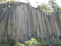
"The top of the post pile looks like a dance floor", Alan told us and he was so right! So of course we had to dance. We posed for pictures and it really was amazing, the smooth surface of the tops of the post piles, polished and striated by a long ago glacier.
It was so like Devil's Tower and yet so different. The post pile itself was a lot smaller, with the columns being the diameter of my Stetson. The post pile screamed to me to climb on, but the signs banning climbing stopped me. Obvious route after route still called. The top of Devils Tower is quite different, but I know you don't want me to describe that, and take away your surprise when you climb it.
We were at Devils Postpile National Monument, a small site on the eastern side of the Sierra Nevadas. Sharon and Alan wanted to share it with us and we were glad that they had! We drove about thiry miles south and west from Lee Vinning, through the town of Mammoth Lakes and on to the Postpile.
Stopping at the visitor center we looked at the aerial images transcribed with the epicenters of earthquake swarms, which usually precede volcanic eruptions. From there we drove down a steep, narrow, and acrophobic seven mile road where the trailhead started, for the Devils Postpile and Rainbow Falls.
The hike itself was pleasant and our bodies told us that we were at over 7000 feet, but it felt so good to be hiking after the days of driving! I wanted to run, the spirit is so willing, but settled for the nice pleasant walk. Sharon and Alan were the perfect tour guides, telling us about their past visits and sharing their stories of family trips and camping and kids.
Too soon we returned to the trailhead, but the joy of discovery wasn't over. Renita spotted a stellars jay and we watched as it begged food from some picnickers. Stellars are a large jay and have a deep blue color and black topnotch. We had seen them before in Wyoming but the more common camp robbers there are the grey jay.
We drove back up the steep road, (did I say there were no guard rails?), but uphill vehicles have the right of way and most of the other cars pulled over. Returning home, Molly greeted us with kisses and her warm puppy greeting. It was a day spent with friends at a beautiful place in the Sierra Nevadas. What could be better? Clear skies,

Tuesday, September 15, 2009

From Lander, Wyoming, to Lee Vinning, California


We left Lander and headed west where our friends Alan and Sharon were already parked outside of Yosemite. The first leg was pretty easy, with no wind across South Pass, and little traffic on our route. We had decided to miss interstate 80 by going north and west through Idaho, before heading south again.
We were pretty much following the Oregon Trail and reminders of it were posted along the way. Renita spent some time behind the wheel, about two hours and it was a good easy drive for her. Farson, and Kemmerer and Diamondville and Cokeville all passed along with a memorial to the coalminers who died in underground mine disasters. We drove by Opal and I thought of how our nephew Blaine had endured a year there.
Crossing into Idaho, the traffic remained light and we thought about staying at Bear Lake,(recommended by Matt and Patty), but we felt good and drove past Pocatello and on to Declo, Idaho. California beckoned.
From Declo we headed west to Twin Falls and then south to Wells, Nevada. As soon as we crossed into Nevada, billboards for brothels started to appear. One advertised "A shot of tequila, cold beer on tap,a good looking lady to sit on your lap". Seeing as I already had a great looking lady and only drink wine nothing really appealed to me.
As we drew near Wells, a spectacular mountain range appeared, the Ruby Mountains. They were a beautiful range and I didn't even know they existed,(When I retired one of my fellow teachers told us that the Ruby Mountains were his favorite place in the USA, and we could see why).
We got on interstate 80 and drove between the Humbolt and Trinity Mountains. We passed the lava flows and a sign at the Forty Mile Desert told of the hardships faced by the pioneers along the California emigrant trail. Renita told me of all the rock art alongside the road, hearts and peoples names stacked on the dried playa lake bed. A crosswind blew, as a weak front was passing, and the driving was harder but the miles still passed by.
We drove through Carson City, past the Comstock Mine and the Moonlight Bunny Ranch.Small casinos dotted the city but we both are pretty much bored by casinos, lucky I guess,(Have you ever seen someone smiling as you walk though them, it seems like you only see that in the commercials).We turned south onto 395 and parked at Carson Valley Rv Park, which is also a casino.
I registered us after we parked and I walked through the casino where the smell of cigarettes assaulted my whole body and I decided not to gamble even with the free coupons given to us at registration. When will this country stop secondhand smoke pollution(I quit smoking myself six years ago and am now a fervent anti smoker!)?
A Traders Joes was back toward Carson City and we restocked our pantry with healthy foods, including Renitas favorite rice. Signs told of our nearness to Lake Tahoe but we had already visited that when I had attended an aerospace convention in Reno long ago. On that trip we had rented a car and spent a day picnicking and driving around the lake and so we ignored the signs, at least on this trip.
The next day we had a late start and turned south into 395, heading to California and friends waiting and new sights to see. The first leg was a steep climb up into the Sierras,(Renita looked them up on a map and said they were called the Sweetwater Mountains). We loved the scenery, it is so much like Jackson Hole, and the Bighorns.
Sagebrush flats were interspersed with pine covered hillsides and hard rock faces above it all.
We crossed two passes before heading down a really steep grade and Mono Lake appeared before us. As we passed it we saw the white mounds of tufa standing above the surface. Our destination appeared and as we turned in we saw our friends Alan and Sharon standing by their fiver, the familiar green ford truck parked along side.It made our hearts felt good, as friend's welcomes always do. Clear skies,

Saturday, September 12, 2009

Eagle Bronze Foundry


While we were staying at Buckboard Crossing Campground we met two full timers, Nancy and David, who highly recommended a visit to the Eagle Bronze Foundry in Lander Wyoming. So it was on our to do list of things while we stayed at Lander waiting for my doctors appointment. They had both said that the tour was amazing and they were right!
Now the Eagle Bronze Foundry isn't the largest bronze foundry in the world, or the one that does the most castings, but it is the one that has done the largest bronze horse and that does the most memorial bronzes. You have probably seen one if you have ever been at a Cabelas, in Dallas, at the EL Paso airport, or any number of places.
It was a complete surprise to us that in little Lander Wyoming such a place existed so when our tour guide, Leslie, proudly showed us the large photos of past projects and we were impressed. We were further amazed as she took us around the foundry and we met the workers who were actually artists, performing their skill in every step of the casting. It was also evident that each of the workers were proud of their work as a skilled artisan, they all literally beamed!
The foundry uses the lost wax method for casting its memorials and its a lengthy process. First, the original clay sculpture is actually destroyed as it is cut into pieces! Each piece is then covered with latex and a wax casting is made. From this wax casting piece a second mold is constructed using sand and ceramic material, which then dries and is used to make the bronze casting.
The casting pieces are then welded together to form the bronze sculpture, which contains an inner iron support, and then sanded smooth before undergoing sand blasting. The next step is the application of a patina or coating which is usually specified by the artist. Finally, the project is approved by the artist before it is fitted to a base and then shipped,(the giant bronzes are actually cut apart for shipping and then rewelded at their final site). Whew, I hope I got most of it right!
To give you an example of the size I took an image of the two bronze horses being cast for a sculpture in Sicily, Italy. Leslie told us such a project can be a multimillion dollar project. She also said that most artists would presell their sculptures as it takes about four sales before the artist breaks even. We had no idea.
She showed us a sculpture that was of forgiveness. It's a religious sculpture concerning the abortion issue and one that touched my soul.
As we left, Leslie told us that the bronze in front of the factory was for sale, at a special price of 150,000. Unfortunately we didn't have room in our fifth wheel so we had to leave the sculpture where it was. We did go the the Eagle Bronze showroom in downtown Lander, where we marveled at the artwork on display.
David and Nancy were right, if you ever go to Lander, Wyoming go take the tour of the Eagle Bronze Foundry, you will not be disappointed! Clear skies.